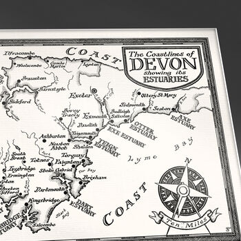
A handsome map of the coasts of Devon, originally drawn by hand, highlighting the county's picturesque coastline and eleven beautiful estuaries.
The first of my 'Counties by Coast' map series, this charming map of the coasts of Devon highlights its eleven beautiful estuaries. Devon is unique amongst English counties in that it has two separate coastlines: on the English Channel in the south, and on the Bristol Channel and Celtic Sea in the north. Major cities and charming coastal towns, adored as holiday destinations for many, are also shown.
The map was drawn by hand using dip-pens and ink in August 2024, and limited edition prints of the map are available in two sizes for 11x14" frames and 14x18" frames.
PRINT/MOUNT OPTIONS - Available print only, or including a mount (mat-board):
• Print Only (worldwide shipping):
- Map prints are rolled and shipped inside a sturdy cardboard tube
• With Mount (UK, USA, and EU shipping only):
- Standard size 11 x 14 inch or 14 x 18 inch (35.6 x 45.7cm) mounts (also known as mat-boards and passe-partouts), so your map is ready to frame.
- Black, ivory, navy, and slate colours to suit a wide range of frames and home decor styles.
- Maps with mounts are shippable to UK, USA and EU destinations.
- Maps with mounts are shipped with Evri or Yodel (standard) or FedEx (express).
PERSONALISATION - This map can be personalised (see picture for examples):
- Option A - £20: an inscription along the bottom border.
- Option B - £30: an inscription added into the map itself.
- Entirely hand-drawn & hand-written onto the print, making it truly unique.
- The style of text can vary between italic or upright, antique, cursive, mid-century, bold or regular. I will contact you to discuss your options in more detail.
- If you desire any other sort of personalisation, please get in touch.
PLEASE NOTE: a frame is not included, but please get in touch if you have any questions about framing your map.


